
Blogs
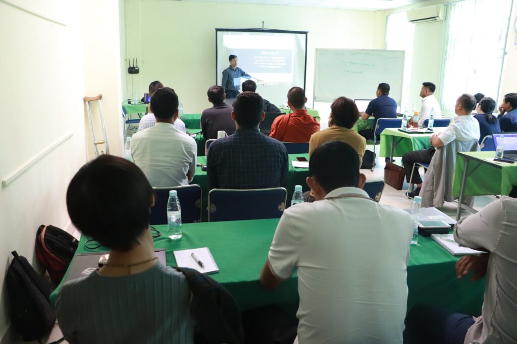
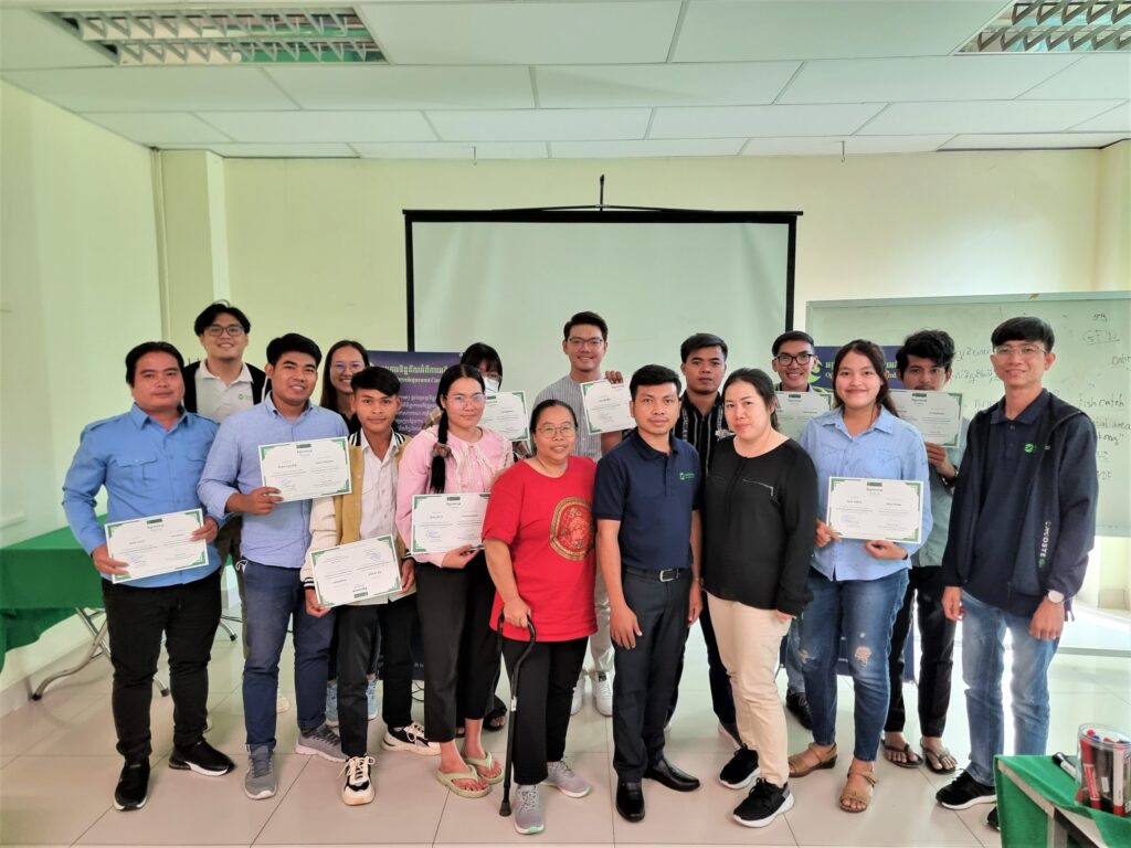
Cybersecurity Training
On 04th July 2023, Open Development Cambodia (ODC) conducted training on cybersecurity for the CSS-cluster members and their networks. The training course aims to raise awareness of the cluster member on cyber security as well as digital security including password management, safe internet browsing, email security, and mobile security. We also provided participants with the essential skill to cope with issues related to cyberattacks and safeguard personal data and accounts. There are 32 participants (12 females) joining the training from ADHOC, NEP, YEA, Epic Arts, CHRAC, SVC, Bophana Center, CENTRAL, LoveIsDiversity, and other networks. To assess capacity, all trainees are required to complete the pre-test. Mr. NGET Moses, Digital Security Consultant, asked each trainee to introduce themselves, their position, organization, and their expectations of the training at the start of the training in order to understand their background and needs. He started the lesson on “password management” by providing an overview of passwords, creating strong passwords, and password managers. The questions were discussed around the topic with actual examples. He continued to the next lesson “safe internet browsing” which highlighted the threats and how to do safe browsing and virtual private network. Email security and mobile security are also very important for trainees. In this session, the trainer demonstrated how to secure mobile devices and emails. The session concludes with a summary of the lessons and a post-test to assess the trainees’ understanding. The evaluation was also requested in order to improve training. One of our trainees, SENG Sokcheat, a member of LoveIsDiversity express, “I think this training is very important as it helps us protect our privacy from online scammers. Also, everyone who is using social media, internet, or other online services should join this training.” The training was conducted under the Learning Platform (LP) project which was funded by the United States Agency for International Development (USAID) through Family Health International (FHI 360) as part of the Civil Society Support (CSS) Project.
National summit on influences of forestry and land regulations on local communities and comprehensive EIA process
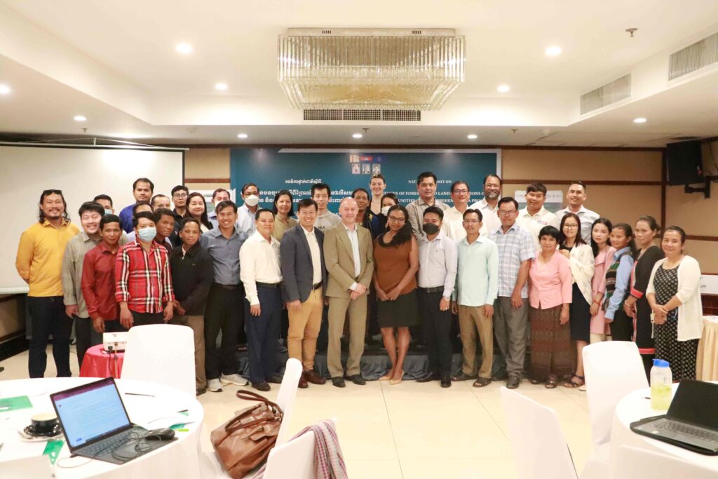
Open Development Cambodia (ODC) organized a national summit on “Influences of Forestry and Land Regulations on Local Communities and Comprehensive EIA Process” on 25 May 2023 with a total of 43 (13 females) representatives from the Ministry of Rural Development (MRD), CSOs, EIA firm, journalists, and indigenous peoples from Ratanakiri, Mondulkiri, Kratie, Pursat, Stung Treng, Preah Vihear, and Kampong Thom provinces. The event was supported by the United States Agency for International Development (USAID) through Family Health International (FHI 360) under the Civil Society Support Activity: Cluster Anchor Grants, and Heinrich Böll Stiftung Cambodia (HBS) under the project of promoting EIA for more transparent and responsive environmental governance in Cambodia. The national summit aims to: Provide an opportunity for relevant stakeholders to express their concerns regarding existing and proposed forestry and land law and associated regulations Identify the effective strategy to provide input into the draft laws Discuss how the proposed law and associated regulations will interact with the EIA process, particularly the engagement of local communities and the public more broadly. The team invited Mr. IL Oeur, Executive Director of Analyzing Development Issues Centre (ADIC), and Ms. YA Yanny, a representative of indigenous women from Mondulkiri province to be the speakers. Mr. THY Try, Executive Director of ODC was the moderator of the panel discussion on “Forestry and land regulations”. The discussion started by introducing the speakers as well as their work. Analyzing Development Issues Centre (ADIC) shared their research on public participation in Prey Preah Roka Wildlife Sanctuary and Chhaeb district, Preah Vihear province. The Ministry of Environment (MoE) had clear guidelines and engaged the local community in the process. They set up numerous local and national meetings for two years to map the areas. This is the first map that engages many people, so there are no concerns raised by the local community during the mapping process. The concern is that when the map is released, who will be responsible for border demarcation? The land inventory is also significant to identify the specific land that each indigenous people own within the communal land title. Then questions were raised around the differences in duration of the indigenous communal land titling and private land title as well as the word usage in the law. A representative from the Cambodia Indigenous Peoples Organization (CIPO) shared the concern on the indigenous community cannot do the rotation or traditional agriculture unless they have been registered. That’s a critical point if the community grows the crop or rice on the land. A response from the MRD, if the community has been recognized as an indigenous group by the ministry, there should not be a problem to use the land. The representative from CIPO also mentioned the concern about excluding the word “Indigenous peoples” in the draft law. Indigenous peoples would like to keep their identity (differentiate from other people) both in the current and upcoming laws. Regarding the input, we would like to see a separate chapter talking about the indigenous people within the Land Law. The discussion between the CSOs and indigenous peoples should be happened before meeting with the related ministries to share their concerns to address in the draft law. The discussion around the reasons for revising or amending the law should be widely disseminated. The government should open for consultation with practical and concerned stakeholders. A representative from 3SPN stated that the draft EIA law excludes the word “FPIC” meaning free, prior, and informed consent. The law encourages to have full public participation in all areas. Fully participation has a different definition from FPIC which considered accessing the information, participation, and decision-making. The participants highlighted that cooperation and working together among key CSOs is very important. By doing so, we could enforce and coordinate the mechanism and inputs effectively. There is an interesting question from the private company regarding indigenous peoples’ economic, livelihood, and materials trends. The question has attacked the attention of indigenous peoples in the rooms to share where they are now. They said, \"Some people get a larger house and modern materials, but some of them have to pay back the loan every month. Some people are poor and do not even have a small area of land to grow crops. What we are now cannot be compared with what we have lost. Although we need to adapt to the modern era, we would not want to lose what we used to have, especially the culture.\" In brief, we discussed the inputs which also reflect several significant points including cooperation among key stakeholders and CSOs in the input gathering and providing to the policy-makers as well as networking with the related ministries, case studies in Mondulkiri, Ratanakiri, and Preah Vihear, and the word usage in the law. The panel discussion on “EIA process: Public participation” brought together Mr. HORM Kimkong, Director of Environmental and Assessment (E&A) Consultancy, Mrs. TEP Tim, a representative of indigenous women from Preah Vihear province, Mr. LEANG Bunleap, Executive Director of 3S Rivers Protection Network (3SPN). The discussion was moderated by Mr. LONN Pichdara, Executive Director of MyVillage Cambodia. Mrs. TEP Tim living in Prame commune, Tbaeng Mean Chey district, Preah Vihear province, said that she did not get an invitation to join the public participation of the EIA process as well informed about the development project beforehand. So far, they only invited the commune and district councils to the meeting. A representative from 3SPN stated that public participation sometimes could provide the opportunity for the company to only gather the people who agree and support the project. The law or regulation on public participation is very important, and it should clearly state who should be invited to join such as from the beginning of the process. “When we are discussing the Land Law, it should also refer to the Cambodian people as well. Why the discussion this morning was focusing on indigenous peoples only?” Question from our participant. Yes, it should be referring to everyone. However, we would like to pay more attention to the indigenous peoples because they are the most vulnerable group among others. From time to time, they live and survive in the forest and do not have any land titles as we do. When there is a development project, they always eye on the forest areas where there are not many people living there. In the case of Cambodia, some projects just process the EIA after a long-term operation. The participants wonder what is the point behind that. EIA is just a tool to assess the impact, not a law. There are three types of EIA implementation including EIA before, during, and after the project implementations. The companies that were established a long time ago do not have EIA since it did not exist at that time. As a result, the MoE review and request them to do the EIA. The new development projects currently must have done the EIA before implementing the project based on the guideline of the ministry. EIA report is very difficult to get. How could we get the EIA reports? Normally, when the report is approved, the consultant, project owner, and the MoE have to stamp each page of the report. Previously, the consultant has to prepare 12 copies, but currently, there are only six copies required which will be kept by the consultant (1), the project owner (1), and the rest will be kept by the EIA Department. The consultant needs to keep the report in a safe place for 3 or 5 years based on the agreement, and they cannot share the report without permission from the project owner. The report could be officially requested from the MoE. Our speakers also suggested the community and CSOs keep all the related documents they provided during public participation. The discussion and content of the provided documents will not have much difference from the approved EIA report. Additionally, the stakeholders should focus on the EIA training for the local community so that they could understand the process as well as the content of the report.
ODC launches a new knowledge-sharing portal called “Learning Platform”
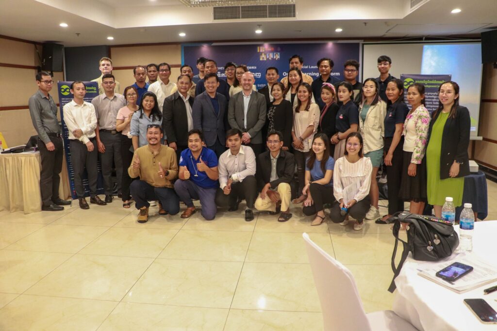
On 04 April 2023, ODC organized an official launch of the online Learning Platform at the Poulo Wai Hotel & Apartment, Phnom Penh, with the participation of 43 people (18 females) from 23 local, national, and international organizations, including cluster member organizations and non-members. Those organizations are NEP, CHRAC, TI, UNDP, BS, CIPL, CIPO, CIYA, Epic Art, WCV, IRAM, 3SPN, HA, FLO, CEDT, ODC, FHI, USAID, KAWSANG, SVC, ADHOC, LAC, and CENTRAL. Twelve of them are from Rattankiri, Kratie, Battambang, Siem Reap, and Kampot. The Learning Platform was developed by Open Development Cambodia (ODC), under financial support from the United States Agency for International Development (USAID) in Cambodia through FHI 360 in partnership with the International Center Not-for-Profit Law (ICNL) for the Civil Society Support (CSS) Project. The Learning Platform aims to be a free one-stop-shop knowledge-sharing portal, aggregating best practices and lessons learned by the cluster members of the Civil Society Support (CSS) project. The portal will disseminate data and information for the wider CSO community and other interested stakeholders through its interactive and user-friendly content, available in both Khmer and English, made publicly accessible and free of charge. The contents of the Learning Platform are classified based on the theme, including education, digital social innovation, environmental and NRM, gender and social inclusion, Indigenous Peoples, journalism, civil society, legal resources, and training materials, which the cluster members implement. The platform is now publicly accessible to cluster members and the public. The user can access the platform through the web address (https://learn.opendevelopmentcambodia.net/) or go directly to the Open Development Cambodia website and find the platform on the Menu bar as a sub-page. The launch event is a significant milestone in the development of the Learning Platform. Through this workshop, we aim to officially introduce the platform and gather feedback from all key stakeholders to improve its look, functionality, and user experience. We also call for increased collaboration on data and resource sharing to ensure the long-term sustainability of the platform. Most of the participants expressed their positive thoughts about the Learning Platform. They said it is an innovative platform that they have been looking for and where they can promote their project and organization’s impact to a broader audience and donors. They also learn from other organizations’ success and experiences in project implementation. At the same time, there were questions from participants regarding content management and the data contribution protocol. In conclusion, the official launch workshop of the Online Learning Platform received positive attention from cluster member organizations as well as non-CSS project partners. Through interactive discussion and constructive feedback, we get several consideration inputs for our team for the next action.
Indigenous peoples sectoral advisory meeting
On 08 February 2023, ODC organized the “Indigenous Peoples Sectoral Advisory Meeting” with the partners, including Conserve Indigenous Peoples Languages Organization, MyVillage Cambodia - MVi អង្គការ ភូមិខ្ញុំ, Forests and Livelihood Organization FLO, Cambodia Indigenous Youth Association-CIYA, and FHI 360 to identify the challenges, activities, roles of the group, and call for new members. The project is funded by USAID Cambodia through FHI 360 under Cluster Anchor Grant from the Civil Society Support (CSS) Project.
Data visualization and storytelling training
Open Development Cambodia (ODC) hosted a training on \"Data visualization and storytelling\" on December 20-21 and 26, 2022, with 24 participants, including journalists, citizen journalists, indigenous youth journalists, journalism students, and CSOs. People with disabilities and LGBTQIA+ are encouraged to join. This training was divided into two parts. The first stage was a two-day online training that included lessons and exercises. The second phase was a one-day physical training session focused on recapping the entire training and exercises. This training was funded by USAID Cambodia through FHI 360 as part of the Civil Society Support (CSS) Project\'s Cluster Anchor Grant. Day 01: Understanding data Before the session began, an ODC representative made a welcoming remark about the project and an introduction to help the attendees get to know one another. Following that, the participant spent time preparing for the pre-test, which was used to assess their capacity before the program began. Mr. Vong Pisith, the trainer, began the lesson on understanding data to provide insight into the importance of data, the different types of data and information, and the transparency of open data. After everyone understood the data well, the trainers demonstrated how to find it using the data portal and Google advanced search. The participants were then given an exercise by finding their needs data in PDF format and other natural resource data on the ODC portal. The trainer, Mr. BAN Chanphalla, then moved on to the next lesson on data standardization, which instructed the participants about data standards and how to format their data before diving into data visualization. The participants were introduced to the function of creating a new spreadsheet, adding sheets, making a copy, columns, and rows, inserting charts, filtering, and pivoting tables on google sheets, as well as importing comma-separated values (CSV) files into the spreadsheet and Microsoft Excel. The trainers also illustrated the data clean as a significant part of the data analysis. This lesson explained why we need to clean data and introduced them to a method for cleaning data to make it legible by introducing techniques such as trimming whitespace, removing duplicates, formatting text, splitting columns, data validation, and finding and replacing. Day 02: Data visualization On the second training day, the trainers took a few minutes to review the previous day\'s lesson before continuing with Mr. Sam An Mardy\'s agenda on data visualization principles. The trainer will introduce what motivated us to create the visualization, what exactly the data visualization is, how to tell a data-driven story, how to choose the right graph and chart type, and how to display it correctly. Mr. Vong Pisith then showed the participants a demonstration and examples of the Flourish. The participants then continue working on the group exercise to create the chart and graph with Flourish. Everyone took the post-test at the end of the second day and looked forward to the physical training on the third day. Day 03: Individual practice The agenda for the last day of training covered lesson reminiscence. Everyone attended the physical training and continued the lesson on data visualization with Flourish. The participants started learning how to make a map chart out of geographical data and how to incorporate those visualizations into the story. Then the participants were given the opportunity to practice it independently and complete the individual assignment by creating storytelling using data visualization. Finally, the trainees were asked to evaluate before closing remarks and provide the training certificates.
The second cluster convention
The second cluster convention was held on 19 December 2022, at the FHI 360 Office in Phnom Penh, with 25 participants (06 females). The convention brought together the Ministry of Land Management, Urban Planning and Construction (MLMUPC), the Ministry of Interior (MoI), civil society organizations (CSOs), community-based organizations (CBOs), media groups, and representatives of indigenous people from Preah Vihear, Ratanakiri, and Mondulkiri provinces. Open Development Cambodia (ODC) hosted the convention, which was funded by the United States Agency for International Development (USAID) through Family Health International (FHI 360) under Cluster Anchor Grant from the Civil Society Support (CSS) Project. ODC is the anchor and collaborates with three cluster members: CamboJA, the Conserve Indigenous Peoples Language Organization (CIPL), and Young Eco Ambassadors (YEA). The project aims to make natural resource management (NRM) more sustainable, inclusive, and participatory by incorporating Indigenous Peoples’ needs and concerns. ODC hosted an initial cluster convention on 13 September 2022 to involve all the cluster members and networks to build the networks, learn from each other, map the significant strategy, and step on further activity on the natural resource management (NRM) advocacy in Cambodia. In this convention, we will update the progress of the indigenous communal land titling in Cambodia, which is a curious and significant topic for today’s talk. The convention aims to: Create a friendly environment for networks to learn and share Keep current updates on the indigenous communal land titling in Cambodia Encourage cluster members and stakeholders to work together. The representative of the Ministry of Land Management, Urban Planning and Construction (MLMUPC) and the Ministry of Interior (MoI) shared the current update on the indigenous communal land titling. Currently, 152 indigenous communities have registered as legal entities with the MoI, while 94 communities have requested communal land titles from the MLMUPC. Due to various challenges and encounters, 26 of these communities were suspended. Some people may be interested in obtaining private land ownership to sell or in obtaining a micro-finance loan. In some cases, the requested land overlaps with natural protected areas and forest cover 2002 established by the Ministry of Environment (MoE) and the Ministry of Agriculture, Forestry and Fisheries (MAFF). Currently, 38 indigenous communities in four provinces have received communal land titles totaling 39,342 hectares: Stung Treng (02 communities), Kratie (04 communities), Mondulkiri (07 communities), and Ratanakiri (25 communities). Two more communities are expected to receive communal land titles by January 2023. The convention also discussed the challenges of land titling. The participants had the chance to question ministries and ask for advice to solve their problems. The process of the land tiling is complicated and time-consuming. The land title sometimes cannot be issued and is suspended due to several challenges. Due to the limitations of the indigenous people\'s knowledge of the Khmer language, legislation, and registration procedures, they always find it difficult to obtain land titles without support from the CSOs and CBOs. In some cases, indigenous peoples are unaware of the benefits of communal land titles. Some community members may see the personal benefits as superior to the sharing and wish to withdraw from the community. It meant that they would like to have their private land title. The local authorities sometimes do not reluctant with the indigenous communities regarding the land titling procedures even though the ministries are trying to speed up the land registration. In many cases, the community refuses to accept the land that the government is willing to provide. After the participatory discussion, the indigenous community is encouraged to document the issues or problems with communal land titling and report them to the working group. ODC will continue to host the quarterly cluster convention with the cluster member and networks to share lessons learned, information, and prioritized issues on natural resource management, environment, forestry, land, indigenous peoples, the strategic environmental assessment (SEA), and environmental impact assessment (EIA).
- « Previous
- 1
- 2
- 3
- 4
- Next »